


 3")
 4")
 5")
Map of Eastern USA: A Complete Travel and Geography Guide
When exploring the map of Eastern USA, travelers and geography enthusiasts discover a diverse region that blends historic charm, natural beauty, and urban energy. Stretching from the Atlantic Ocean to the Mississippi River, the eastern half of the United States is home to some of the nation’s most influential cities, scenic landscapes, and iconic landmarks.
Whether you’re studying American geography or planning a trip, understanding the map of Eastern USA helps you navigate through bustling urban areas like New York and Boston, scenic mountain ranges like the Appalachians, and coastal havens such as Florida and the Carolinas.
The eastern region of the United States represents the cultural heart and historical backbone of the nation — where the country began, where major battles were fought, and where innovation continues to thrive.
Contents
- 2. States Included in the Eastern United States
- 3. Geographical Features of the Eastern USA
- 4. Major Cities and Metropolitan Hubs
- 5. Climate and Weather Across the Eastern States
- 6. Eastern USA Map and Regional Highlights
- 7. Popular Tourist Destinations in the East
- 8. Transportation and Connectivity
- 9. Cultural and Historical Importance
- 10. Economy and Lifestyle in the Eastern United States
- 11. Educational Institutions and Research Centers
- 12. Final Thoughts
- Author
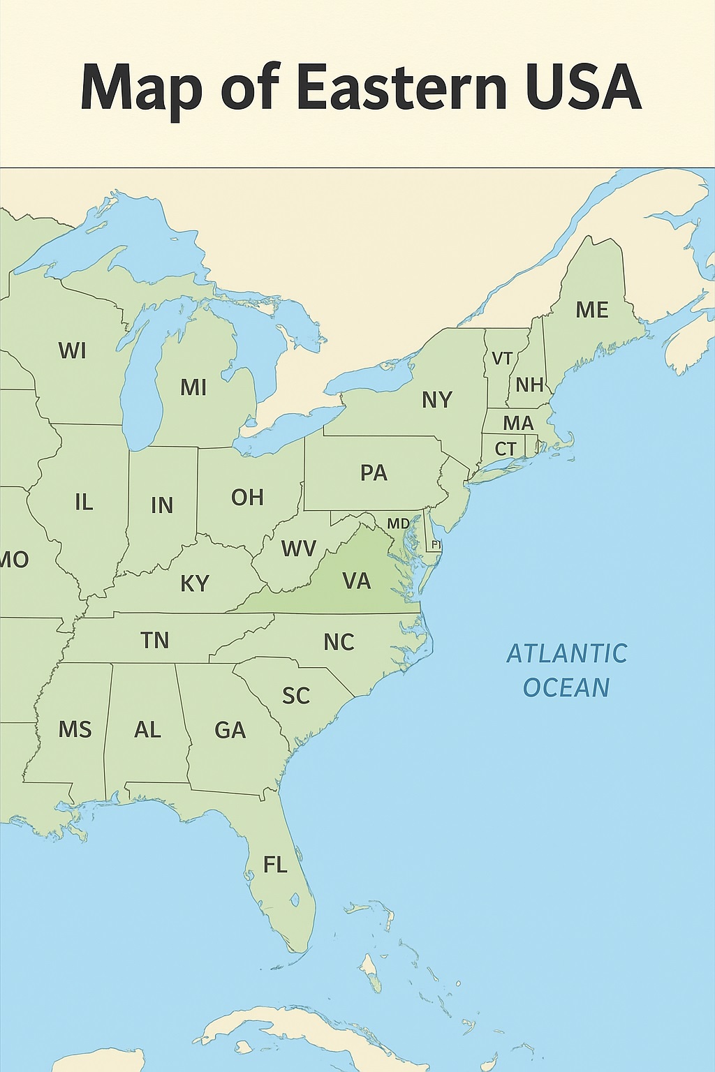
2. States Included in the Eastern United States
The Eastern USA is typically defined as all states located east of the Mississippi River. Depending on the classification used by geographers or federal agencies, it includes anywhere from 26 to 28 states.
Here’s a complete list of the Eastern USA states:
-
Northeast: Maine, New Hampshire, Vermont, Massachusetts, Rhode Island, Connecticut, New York, New Jersey, Pennsylvania
-
Mid-Atlantic: Delaware, Maryland, Virginia, West Virginia, Washington D.C.
-
Southeast: North Carolina, South Carolina, Georgia, Florida, Alabama, Tennessee, Kentucky, Mississippi
-
Great Lakes Region: Ohio, Indiana, Michigan, Wisconsin, Illinois
Each of these states contributes unique features to the map of Eastern USA — from New England’s colonial towns to Florida’s sun-soaked beaches.
3. Geographical Features of the Eastern USA
The geography of the Eastern United States is as diverse as it is stunning. Some of the region’s most notable features include:
-
Appalachian Mountains: Stretching from Alabama to Maine, this ancient range forms the scenic backbone of the East. Popular destinations include the Blue Ridge Mountains and the Great Smoky Mountains.
-
Atlantic Coastal Plain: Extending from New York down to Florida, this low-lying area offers fertile farmland, marshlands, and beautiful beaches.
-
Great Lakes: Located in the northern region, these freshwater lakes—Superior, Michigan, Huron, Erie, and Ontario—serve as a major waterway system.
-
Mississippi River: Serving as the western boundary for many Eastern states, it’s one of the world’s most important river systems.
The map of Eastern USA is truly a mosaic of terrains—rolling hills, forested mountains, coastal plains, and bustling metropolises.
4. Major Cities and Metropolitan Hubs
The Eastern USA is home to some of the country’s most populous and economically powerful cities.
-
New York City, New York: Known as “The City That Never Sleeps,” NYC is a global financial and cultural capital.
-
Boston, Massachusetts: A historical hub of education and innovation, Boston is home to Harvard and MIT.
-
Philadelphia, Pennsylvania: The birthplace of American independence, with landmarks like Independence Hall and the Liberty Bell.
-
Washington, D.C.: The nation’s capital, rich with museums, monuments, and political significance.
-
Atlanta, Georgia: A thriving business and transportation hub, home to major corporations and the world’s busiest airport.
-
Miami, Florida: A vibrant coastal city famous for its beaches, nightlife, and multicultural energy.
-
Chicago, Illinois: Located on Lake Michigan, it bridges the Midwest and Eastern regions economically and culturally.
These cities, when viewed on the map of Eastern USA, form a dynamic network of innovation, commerce, and history.
5. Climate and Weather Across the Eastern States
The climate of the Eastern USA varies widely due to its vast north-to-south stretch and diverse geography.
-
New England: Cold winters and mild summers. Snowfall is common from December to March.
-
Mid-Atlantic: Four distinct seasons; warm summers and chilly winters.
-
Southeast: Subtropical to tropical climate with humid summers and mild winters.
-
Great Lakes: Cold winters with lake-effect snow and pleasant summers.
This variation in climate shapes the lifestyle, agriculture, and tourism appeal throughout the region. For example, Maine is perfect for snowy getaways, while Florida remains a year-round vacation destination.
6. Eastern USA Map and Regional Highlights
On the map of Eastern USA, the region is often divided into several subregions to better understand its diversity:
-
New England: Known for its fall foliage, historic towns, and coastal charm.
-
Mid-Atlantic: Blends urban density with political and historical importance.
-
Southeast: Features warm weather, beaches, and Southern hospitality.
-
Great Lakes Region: Industrial powerhouses mixed with natural beauty.
From the Great Smoky Mountains in Tennessee to Acadia National Park in Maine, and from Niagara Falls in New York to the Florida Keys, the eastern half of the United States offers an unmatched range of experiences.
7. Popular Tourist Destinations in the East
If you’re planning a road trip using the map of Eastern USA, here are some top destinations worth visiting:
-
New York City, New York – Times Square, Central Park, Statue of Liberty
-
Boston, Massachusetts – Freedom Trail, Fenway Park, Harvard Square
-
Washington, D.C. – Smithsonian Museums, National Mall, U.S. Capitol
-
Orlando, Florida – Walt Disney World and Universal Studios
-
Savannah, Georgia – Historic architecture and Southern charm
-
Asheville, North Carolina – Blue Ridge Parkway and Biltmore Estate
-
Chicago, Illinois – Millennium Park and Willis Tower
-
Niagara Falls, New York – One of North America’s natural wonders
These attractions are clearly marked on detailed maps of Eastern USA, helping tourists plan routes that balance city sightseeing with natural exploration.
8. Transportation and Connectivity
The Eastern USA is extremely well-connected, making travel between states seamless.
-
Highways: The Interstate Highway System includes I-95 (East Coast), I-75, and I-90, linking major cities from north to south and east to west.
-
Air Travel: Major airports such as JFK (New York), ATL (Atlanta), and MIA (Miami) serve millions of travelers annually.
-
Rail: Amtrak operates extensive train routes, especially along the Northeast Corridor.
-
Public Transport: Subway systems in cities like New York, Washington D.C., and Boston ensure efficient urban mobility.
This level of infrastructure enhances both tourism and business connectivity across the region.
9. Cultural and Historical Importance
The Eastern United States is often referred to as the birthplace of America. It’s where the nation declared independence, wrote its Constitution, and fought many defining wars.
-
Boston & Philadelphia: Centers of revolutionary history.
-
Virginia & Maryland: Colonial roots and early settlements.
-
Washington, D.C.: The seat of government and symbol of democracy.
Culturally, the East Coast also gave rise to jazz, hip-hop, and major literary movements. The map of Eastern USA reflects this deep cultural density—with each state boasting unique festivals, cuisines, and traditions.
10. Economy and Lifestyle in the Eastern United States
Economically, the Eastern USA drives much of the nation’s productivity. It’s home to:
-
Financial hubs: New York, Boston, and Chicago.
-
Technology and research: Massachusetts and North Carolina’s Research Triangle.
-
Manufacturing and shipping: Great Lakes states and Atlantic ports.
-
Tourism and hospitality: Florida, Georgia, and the Carolinas.
The lifestyle varies dramatically—from the fast-paced energy of cities to the relaxed coastal vibes of the Southeast. This diversity makes the Eastern USA a microcosm of the entire country.
11. Educational Institutions and Research Centers
The map of Eastern USA is dotted with world-class universities and research institutions, making it a global hub for education.
-
Harvard University (MA)
-
Yale University (CT)
-
Princeton University (NJ)
-
University of Pennsylvania (PA)
-
Duke University (NC)
-
University of Florida (FL)
-
University of Chicago (IL)
These centers of learning attract international students, scholars, and innovators, contributing to the region’s reputation for excellence and thought leadership.
12. Final Thoughts
Exploring the map of Eastern USA reveals a region brimming with history, innovation, and natural beauty. From the cobblestone streets of Boston to the sunlit shores of Miami, every corner of the East tells a story of America’s evolution.
The East’s blend of cultural heritage, academic excellence, economic power, and environmental diversity makes it a truly remarkable part of the country. Whether you’re a student, traveler, or professional, understanding this region offers valuable insights into the heart of the United States.